This post is in continuation to https://thetravelingcapri.com/trippin-tassie-part-i/ and covers South- East-North of Tasmania.
Day 7 : Peter Murrell Conservation Area-Mount Wellington
We returned to Kettering from Bruny by ferry and drove towards Peter Murrell Conservation Area, to try our luck with the endangered 40-spotted Pardalote. This reserve comprises of dense Eucalyptus and gum trees with multiple walking and fire trails. The reserve’s effort on placing small bird houses on these trees to encourage breeding and conservation of these birds is noteworthy. Pardalotes are tiny and timid birds; extremely difficult to spot. After 2-3 hours of exploring the reserve, we found a decent population of birds including Pardalotes (not sure if one of them was 40-spotted).

We passed through Hobart, the capital of Tassie. I loved how Hobart is modern, yet retained the charm of its colloquial Anglo buildings and houses. Visit the Salamanca market and the Mona Art Museum if you can spend a day here. We however, chose to visit Mount Wellington (Mt Kunanyi) peak instead. Situated at 4170 ft, Mount Wellington offers breath taking views of the Dolorite mountains and unrestricted views of Hobart and beyond.

Day 8: Port Arthur
This historic world heritage site should be on your hitlist. We booked the ‘Ghost Tour’ of Port Arthur Ruins that bought to life its heart-wrenching stories of the penal settlement atrocities from the 19th century and narrated presence of paranormal incidents that directly related to the prisoners, inmates of the confinement cells, asylum and execution. This tour happens post twilight and is an experience not to be missed! The tour was so impactful, that I ended up digging its convict stories for several days upon return!
Tip : The mementos at the visitor centre are the best to pick up as return gifts. There is an impressive collection of books on Port Arthur worth picking up.
Campsite for day 7 & 8: NRMA Porth Arthur Holiday Park. Vast. Powered/ Unpowered. Hot Shower. Well equipped.

Day 9: Tasman Cruise by Pennicott Journeys. Spectacular half day tour sailed us approx. 25 kms into the rugged Tasman sea. This is the closest one could get to Tassie’s remote wilderness. Wild fur seal colonies, nesting sea-bird families, swimming dolphins, fishing albatrosses and ice-age old, sky-piercing, organ pipe-shaped Dolorite rock formations – this tour had it all!! If you are lucky, you might also get to see a hump-back whale (we were able to spot its blow from a distance!). The guides were warm and enthusiastic and provided great insights into the history of the Tasman sea. Advance booking recommended!

The Eaglehawk neck look out is another isthmus, this one connects the Tasman peninsula to Tassie. It is said that during the convict era, this isthmus used to be guarded with ferocious dogs; making any attempted escape by convicts next to impossible. A few kms ahead lies the Tessellated Pavement; naturally evolved rock formations that seem like a manmade platform of rectangular blocks of rocks placed in neat rows to form a large pavement. I was somehow convinced that this precision was too perfect to be natural, but I was wrong.
NOTE: Tessellated Pavement should be visited at sunrise to capture brilliant colors of the morning sky.

Day 10: Maria Island
Driving towards the east coast, our next pitstop was Maria Island- known for its unique and colorful rock cliffs. The only way to reach Maria is via a ferry from Triabunna. There are no camping/kitchen facilities here, hence this has to be done as a day trip unless you are planning to trek with all your luggage. Vehicles cannot be boarded on the ferry. We did the Painted Cliff walk (2 hours return), encountering scores of wombies, wallabies, roos and pademelons including a Wombie joey! This sanctuary has a protected nesting ground for Oyestercatchers. We also spotted the endemic and rare Cape Barren Goose alongside ducks and other water birds.
MUST DO: A small shop called ‘The Fish Van’ near the ferry boarding point at Triabunna serves finger-licking fish and chips in satisfying quantities at just AUD 12. Keep at least an hour at hand since this joint is super crowded despite lightning-fast service.
Campsite: Triabunna Campsite. Very crampy. Paid site. Average kitchen. Powered & unpowered. Paid shower.


Day 11: We left Triabunna next morning for some beach hopping on the stunning coastline of the Freycinet National Park visiting the Hazard beach, friendly beaches, honeymoon bay beach and few others. If you are a mussel/oyster lover try the Freycinet Mussel farm for their platters. Evening called for an hour-long trek to the Wineglass bay look out for panoramic vistas of white sands and sparking blue waters. Mount Amos is a 4 hour grade 4 trek that provides a full view of the wineglass bay. We skipped it as we found the views from the look-out equally satisfying!
Campsite: Freycinet Paintball: Basic. Paid shower. No Kitchen. Campsite far away from the toilet. Book by email/call.

Day 12 : Bicheno blowhole, is a natural geyser formed on a huge granite rock. When tides hit the rock, water splurges at least 20 feet high from the blowhole in full force.
Pub in the Paddock : We zoomed past acres and acres of scenic countryside comprising of pretty villages, rolling green fields and muddy roads. We decided to relish some beer at the oldest pub in Tasmania called pub in the paddock. Unfortunately, it was closed this day. However, I did see Pricilla, the famous beer drinking pig at the paddock accompanied by a bleating sheep. She was the fattest pig I’d seen in my life and was so sloshed out that she did not bother to react to my nudges or calls. Next to her was a barrel half-full of empty beer bottles emptied by her 🙂 Click here to enjoy a quick video of Pricilla https://youtu.be/zwzYvXzCn1Q
What fascinated me about St Columba falls is the story of the fearless, Annie Beechey who went all alone into the deep forest to find her lost cow and lost her way in 1908. When the police failed to trace her, they were convinced that she wouldn’t have sustained the harsh winter in a forest so dense. However, Annie surprised everyone by returning to her family of 6 children and her husband after 9 days later, surviving 2 Tasmanian tigers who stalked her for two days in the forest. She was found in torn clothes, starving, pale and leaning on a bush stick by two men wandering in the forest. Despite having her toes amputated later as a result of the frostbite, Annie had survived! A hair-raising heroic tale of Annie, the Iron lady who hailed as the bravest Australian woman in 1908!
Day 13: Bay of Fires: The presence of lichens gives the granite boulders of Bay of Fires its vibrant orange color. Bay of Fires has numerous outlets to its coastline and you can have a piece of the beach entirely to yourself, just like we did! Keep driving ahead until you find a spot you love! We prepared our morning breakfast on the beach, soaking up the sun with no other soul in sight. Camping is not permitted though. Tides bring varieties of dead jellyfish to the shores.
Campsite: Policeman’s Point Campsite. Basic. No shower. Dry Toilets. First come first serve.

We continued on the fringes of the Mount William National Park and diverted inwards, stumbling upon a hidden gem called ‘The little Blue lake’. The man made lake is a result of mining. Though charming, it is contaminated by metallic toxins. Perfect place to get your ‘instagram’ selfie but swimming is prohibited!
Campsite: Camp4Stumpys. First come first serve. Basic. Dry toilet. No shower. No kitchen. Extremely Crowded.

Day 14: Proceeding on our last lap to Narwantapu via the scenic Derby village, we digressed towards Bridestowe Lavendar farm at sunset. We missed tasting their lavender ice-cream as we reached well after they had shut for the day. But the owners were kind enough to permit us to visit their fields. Bridestowe’s lavender field is massive and impressive. The unending rows of neatly stacked lavenders plantations gently swaying in the cool breeze under the orange hues of the fading sun with the sweet scent of lavender lingering all over was a moment to behold!
Campsite: Springlawn Campsite, Narawntapu. Par excellence! Massive and widely spread. Hot showers. Kitchen. Visitor centre. Paid site.

Day 15-16: Narawntapu National Park
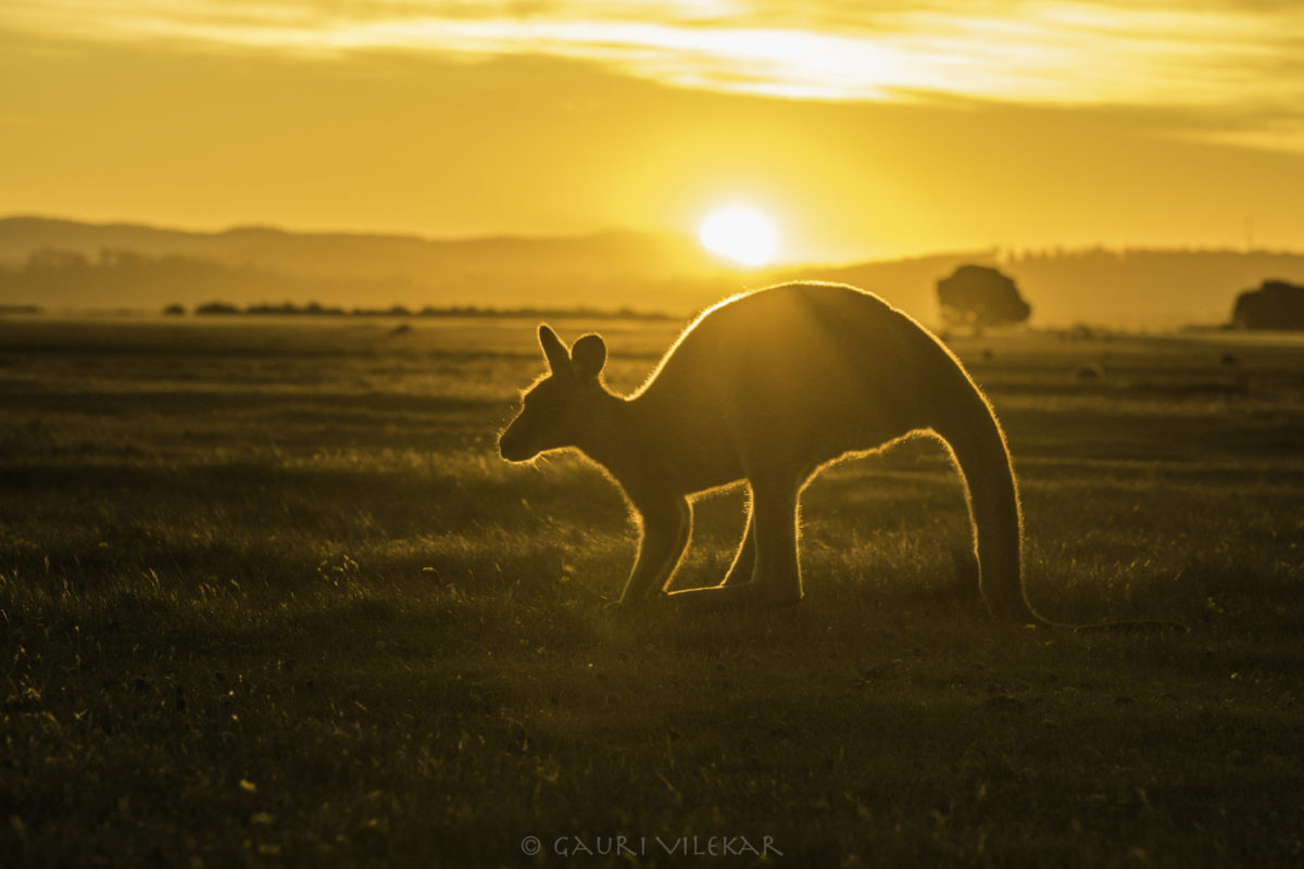
Narawntapu was the last leg of our road trip and I am so glad that I reserved 2.5 days for it. The pristine, and fairly untouched Narawntapu is best for spotting Tasmania’s wildlife. The topography here is a mix of grasslands, forests, scrubs, wetlands and the coastline. I strolled in the vast open grasslands where hundreds of Kangaroos, wallabies, wombats and pademelons had put up a grazing show at sunset. We did the 13 km Copper Cove trail – a combination of straight walk and gradual ascend with spectacular views of the coast and changing landscape. This trail also has a birdhide overlooking a swamp, presenting decent views of the waterbirds. The tail end of the trek leads you to a long rock patch where copper mining was prevalent during the European era. The Bakers beach to Badger Head trail, is a long trek comprising of a few kilometers walk on the Narawntapu’s virgin beach strip, followed by a zig-zag ascend to the Badger head, another long walk to the Badger head and return via the same route. We had time enough to almost reach the top of the Archers Knob trek before we could wind up our trip. It’s no exaggeration that Narawntapu National Park is referred to as the ‘Serengeti of Tasmania’.

Day 17: Back to Devonport and Return to Melbourne via the Spirit of Tasmania.
Click https://thetravelingcapri.com/trippin-tassie-part-i/ for Part 1 of my road trip
This brings me to the end of my trippin’ in Tassie. If you have any questions, feel free to get in touch via my contact page. See you there!
Part II routemap
